Widespread and Harmless, Garter Snakes are Anything but Mundane.
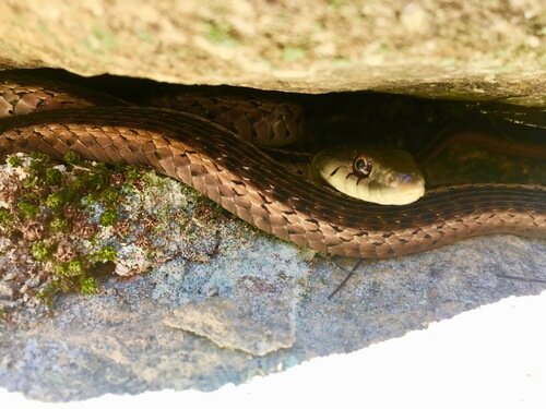
A common garter snake hides out between boulders near Asheville, North Carolina.
This short essay is meant to accompany a recent article I wrote for Atlas Obscura about what Oregon State University’s massive collection of garter snakes tells researchers about climate change. The article subsequently appeared on Mother Jones and Canada’s National Observer as part of a collaborative climate desk between the publications! Read the original article here and the Mother Jones version here!
If you’ve seen a snake in North America, there is a good chance it was a garter snake. Found from the dense jungles of Central America to the edge of the Canadian arctic, the thirty-some species of garter snake dominate the continent. No species embodies this geographic takeover like the common garter snake, the most widely dispersed reptile in North America; one subspecies, the eastern garter snake, is the state reptile of Massachusetts while another subspecies, the Puget Sound garter snake, is found clear across the continent in the temperate rainforests of Vancouver Island.
Although remarkably common, these snakes are anything but mundane. In Guatemala, black-neck garter snakes are armed with a foul-smelling musk they can emit like a skunk when a predator threatens. Up in Manitoba each spring, tens of thousands of red-sided garter snakes exit their hibernation dens to mate in massive, seething tangles as if part of a biblical plague. A few months later, the female red-sided garters give birth to live young (a common trait of the genus), sometimes as many as 80 at a time. They are also incredibly diverse. While shorthead garter snakes in Pennsylvania can measure as short as 10 inches and only weigh a couple ounces, giant garter snakes in central California’s marshlands can stretch some 64 inches from snout to tail and weigh a pound and a half.
Most are also incredibly beautiful, sporting intricate stripes that run along their serpentine bodies. They reminded at least one scientist of the garters used to hoist up stockings. But several take their appearance to another level, none more so than the San Francisco garter snake. These endangered serpents pop in a vibrant tapestry of crimson and turquoise scales and have been hailed as the most beautiful snake in North America according to the U.S. Fish and Wildlife Service.
But beyond diversity and deceptive beauty, garter snakes tell us a remarkable amount about our world: within their biology lies evolutionary secrets for everything from aging to reproduction. For example, scientists have discovered that garter snakes have “unique and consistent personalities” shaped by their environments. Others have explored how these mildly venomous snakes (of no danger to humans) greedily eat poisonous newts. According to a 2018 paper, their immunity to these toxins have made garter snakes “an important model for studying the evolution of toxin resistance.”
As one of the few reptiles to possess a sequenced genome, garter snakes have also become a darling of the comparative biology field. Their genes have been analyzed to explain the evolution of cancer-fighting proteins and insulin-producing systems in other reptiles and mammals. Within these seemingly mundane serpents exists some of our very own history. In the 2011 proposal to sequence the garter snake genome, researchers concluded that “It would provide a genome for a critically important lineage of amniotes [reptiles and mammals] and…will ultimately improve our understanding of the human genome.”
Most individual garter snakes are far from remarkable. They do not threaten with deadly venom like rattlesnakes or awe with power like anacondas. They do not attract attention on the news or social media like the pythons in the Everglades or the occasional snake that improbably ends up in someone’s shower. But as a whole, it would be hard to argue that any group of snakes has been more successful than the garter snakes. Whether squirming through your front yard or caught in a tangle up in Manitoba, each of these resilient serpents can teach us a lot about our changing world.
For more snake coverage, check out: